Product Overview
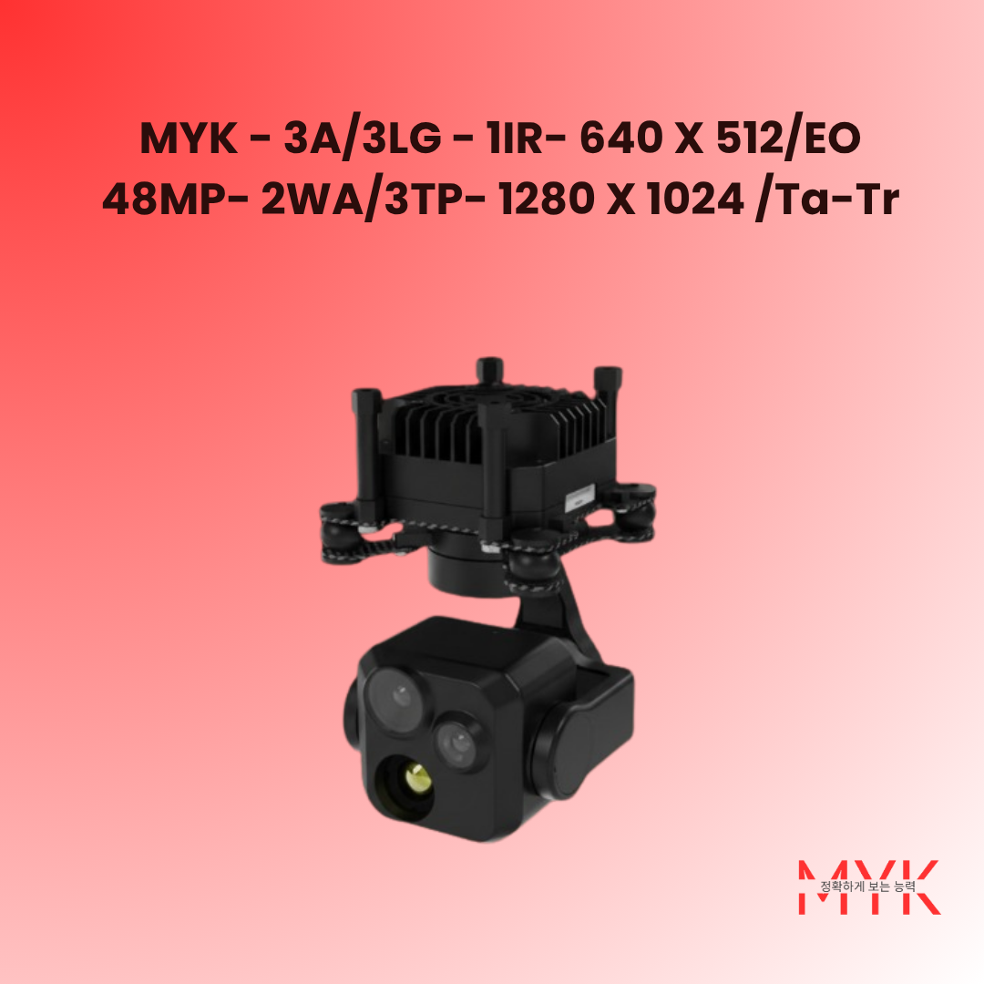
MYK – 3A/3LG – 1IR- 640 × 512/EO 48MP-2WA/3TP- 1280 × 1024 /Ta-Tr is a three-axis three-light gimbal camera that integrates an uncooled infrared thermal imager, a 48-megapixel wide-angle camera, a 48-megapixel telephoto visible light camera, a three-axis servo stabilized platform, and an image tracker. The lightweight, highly integrated system delivers high stabilization accuracy, automatic target recognition, and automatic tracking for persistent surveillance.
Designed for small unmanned aerial vehicles with a wheelbase under 50 cm, the payload enables day-and-night situational awareness, long-endurance target tracking, and rapid deployment in complex environments.
Key Features
- Uncooled LWIR sensor with electronic zoom and multi palette support
- Dual 48MP EO channels covering wide-angle and telephoto perspectives
- Three-axis servo-stabilized platform with ±0.007° precision
- Automatic target recognition, locking, and resilient tracking
- Real-time IR and EO outputs with PiP display and video recording
- Network control via UDP with RTSP/UDP streaming
- Lightweight ≤200 g payload optimized for compact UAV integration
- Onboard storage using MicroSD cards up to 512 GB
Product Functions
a) Automatic recognition and tracking of typical targets
b) Dual-band detection with infrared and visible outputs
c) Infrared electronic zoom and multi palette switching
d) Three-degree-of-freedom motion (azimuth, pitch, roll)
e) Stabilized optical axis compensating carrier disturbances
f) Target lock/unlock with tracking frame overlay
g) Resilient automatic tracking against natural interference
h) Tracking point switching for flexible target management
i) UDP network control with RTSP/UDP video streaming
j) Photo capture and video recording functions
k) Picture-in-picture viewing for enhanced situational awareness
Mounting Platforms
Small rotary-wing unmanned aerial vehicles.
Main Technical Parameters
Thermal Imaging Camera
| Parameter |
Specification |
| Detector Type |
Uncooled Focal Plane Detector |
| Working Waveband |
8 μm – 14 μm |
| Resolution |
640 × 512 |
| Pixel Pitch |
12 μm |
| Focal Length |
9.1 mm |
| Field of View |
48.7° × 38.6° (±5%) |
| Temperature Measurement Mode |
Spot and area temperature measurement |
| Temperature Range (High Sensitivity) |
-20 ℃ to +150 ℃ / ±2 ℃ or ±2% |
| Temperature Range (Low Sensitivity) |
0 ℃ to +500 ℃ / ±3 ℃ or ±3% |
| Over-temperature Alarm |
Yes |
| Color Palettes |
≥10 types |
| Digital Zoom |
8× |
| Image Capture |
1280 × 1024, JPG |
| Video Output |
1280 × 1024, MP4 |
Telephoto Camera
| Parameter |
Specification |
| Sensor Size |
1/2" CMOS |
| Effective Pixels |
48 MP |
| Lens Focal Length |
25 mm |
| Field of View |
14° × 8° (±5%) |
| Image Capture |
8000 × 6000, JPG |
| Video Output |
4K @30 fps / 1080p @60 fps, MP4 |
Wide-angle Camera
| Parameter |
Specification |
| Sensor Size |
1/2" CMOS |
| Effective Pixels |
48 MP |
| Lens Focal Length |
4.5 mm |
| Field of View |
78° (±5%) |
| Image Capture |
8000 × 6000, JPG |
| Video Output |
4K @30 fps / 1080p @60 fps, MP4 |
Servo Platform
| Parameter |
Specification |
| Azimuth Rotation |
±150° |
| Pitch Rotation |
-135° to +45° |
| Roll Rotation |
-45° to +45° |
| Stabilization Accuracy |
≤±0.007° |
System Indicators
| Parameter |
Specification |
| Image Tracking |
Yes |
| AI Recognition |
Automatically detect and identify typical targets |
| Storage |
MicroSD ≤512 GB |
| Rated Operating Voltage |
12 VDC |
| Voltage Range |
10 V – 26 V |
| Weight |
≤200 g |
Interface
| Parameter |
Specification |
| Control Interface |
UART / Network (UDP) |
| Video Interface |
100 Mbps network (RTSP / UDP) |
| Storage Interface |
Memory card ≤512 GB |
Environmental Adaptability
| Parameter |
Specification |
| Operating Temperature |
-20 ℃ to +55 ℃ |
| Storage Temperature |
-40 ℃ to +60 ℃ |
Mechanical Dimensions & Installation
Refer to the product brochure for detailed mechanical dimensions and mounting interface diagrams.
Applications
Optimized for lightweight UAV missions requiring rapid deployment, multi-sensor fusion, and persistent tracking across varied environments.
🛰️
Border & Perimeter Security
Continuous monitoring of critical ground corridors.
🚁
Search & Rescue
Locate missing persons with dual-band sensing.
🏞️
Environmental Monitoring
Assess forests, coastlines, and ecological zones.
🏭
Infrastructure Inspection
Inspect utilities, pipelines, and industrial assets.
👮
Public Safety
Enhance tactical awareness for law enforcement.
🌾
Precision Agriculture
Monitor crop health and thermal anomalies.